IDNO
DG.144834.SHP
Description
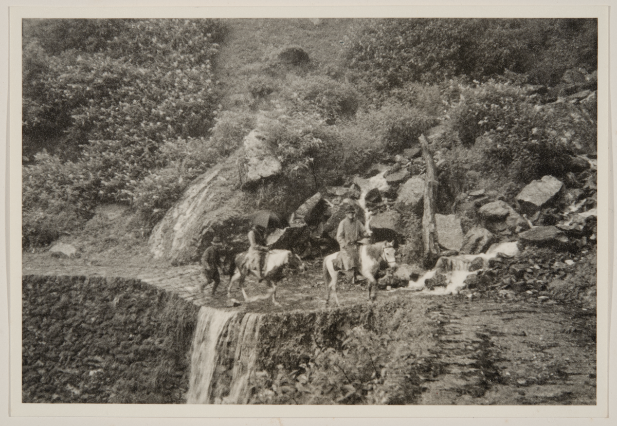
"Crossing an Irish-bridge just beyond Karponang en route to Changh. Ken Shepheard leads the convey in heavy rain through lovely Himalayan flowers."
Place
S Asia; India; Sikkim; Karponang; Changh; Himalaya
Cultural Affliation
Named Person
Ken Shepheard
Photographer
Jack, Archibald (Archie) Frederick Maclean (Leuit., R.E.)
Collector / Expedition
Date
8 - 9 August 1938
Collection Name
Shepheard Collection
Source
Shepheard Rogers, Patricia
Format
Album Print Black & White
Primary Documentation
Other Information
Related Archive: Noted in Shepheard's diary 'Some Notes of Ken Shepheard on his expedition to Lhasa, Tibet, in September - October 1938' pp.8-10,
"8 Aug 1245 left Gangtok with 4 riding and 6 pack ponies - five
hours late after a long haggle. Through mist, cloud
and heavy rain along precipitous climb to
Karponang.
Arr 1645 Gangtok 6000’
Karponang (Phusum) 9000’"
First five miles average grade 1/10, motorable width -- side slope average 1/3. Second five miles -- average grade 1/8, cobbled and narrow, side slope precipitous, average 2/1.
Largely supported on dry stone walls very overgrown and not possible to estimate their heights or foundations -- in places rock undercut. No catchwater drains, many scuppers and culverts.
Last five miles n.b.g. on present alignment. Very heavy rainfall, scuppers essential at least every 100x.
Soil - first 5 miles, alluvial, black and boulder. Second 5 miles, continuous rock and very heavy undergrowth throughout.
Karponang R.H. delightfully situated on a spur with room behind and above it to camp one battalion. RH. spacious with large rooms and verandah. Fuel plentiful. No supplies.
Drank “chang” out of a bamboo “bottle”.
Lots of leeches -- ‘ware rearing in the open!
9 Aug 1938 Karponang to Tsomgo (12,500’)
Left 0815 arrived 1330 hrs.
Rain all the way and thick mist most of the time.
Road First three miles similar to yesterday but narrower and steeper side slope. Alternative route not kept up and no longer passable. Line not practicable for M. T.
Lagyap La (mile 3) to Tsomgo country more open and side slope less steep - average 1/4.
Camping, scattered, possible over most of this stage. Road alignment possible for M.T. with local realignments and easing of grade. Widening possible by machinery.
Fuel and grazing plentiful throughout.
Fuel for Tsomgo within 1 mile -- tree line stops just below lake.
Camping grounds at each end of lake each for 1 battalion.
Lake, when frozen, possible landing but difficult a/c nearness of hills on either side and at top end. 3/4 mile x 1/2 mile
Not up to R.A.F. specification for this height.
Supplies, only one acre seen under cultivation, nil
Possible alignment of M.T. road from Gangtok to Lagyap La ?? (see map.)" [JD 26/01/2020]
FM:282738
Images (Click to view full size):