IDNO
LS.115778.TC1
Description
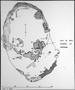
A map showing an unidentified cave, roughly 60 yards by 80 yards. The overhang of the ground above the cave is shown by a labelled dotted line. [JD 31/8/2012]
Place
N Africa; Libya; northern Cyrenaica; Gulf of Sirte
Cultural Affliation
Named Person
Photographer
None
Collector / Expedition
McBurneys and Hey’s Expeditions to northern Cyrenaican, 1947, 1948, and 1952
Date
circa 1947 - 1952
Collection Name
Teaching Slide Collection
Source
Format
Lantern Slide Black & White
Primary Documentation
Other Information
Given that they were near to each other in the order the slides were found in, this map could be showing the cave shown in LS.115776.TC1 (two slides before)? The map does depict an cave as we see. [EMR 31/8/2012]
FM:250428
Images (Click to view full size):