IDNO
LS.109234.TC1
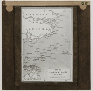
Description
On Catalogue Card: "Torres Sts.
Map of Torres STs & Daudai." [manuscript in ink]
On Catalogue Card for duplicate print P.683.ACH1: "Map".
Drawing entitled ‘Map of Torres Straits’ showing the Islands, tip of Cape York Peninsula, Queensland and British New Guinea from Bamu River to Mai Kassa river. [Jude Philp 6/2/1998]
Place
Oceania Australasia; Oceania Melanesia; Australia; Papua New Guinea; Torres Strait; Queensland; Cape York Pennisula; Bamu River; Mai Kassa river [British New Guinea]
Cultural Affliation
Named Person
Photographer
None
Collector / Expedition
Haddon, Alfred Cort
Date
?1890
Collection Name
Teaching Slide CollectionHaddon Unmounted Collection
Source
Haddon, Alfred Cort (Dr)
Format
Lantern Slide Black & White
Primary Documentation
Other Information
Publication: This map is used as the frontispiece to each of the Reports of the Cambridge Anthropological Expedition to Torres Strait, but was probably made after Haddon’s 1888 Expedition from London Missionary Society maps. [JD 23/2/2012]
MAA Exhibition: Same image included as frontipiece in 1920s Exhibition Case Binders "Cases 5-10. Torres Strait." (OA2/16/4). [JD 07/09/2021]
FM:243884
Images (Click to view full size):