IDNO
LS.75414.MCBUR
Description
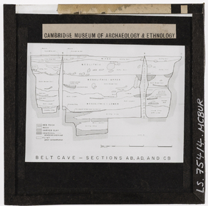
A drawing of the stratigraphic profiles from the 1949 and 1951 excavations of the Belt Cave (Ghar-e Kamarband) in northern Iran
Place
W Asia; Iran; northern Iran; Ghar-e Kamarband [Belt Cave]
Cultural Affliation
Named Person
Photographer
None
Collector / Expedition
Date
circa 1951
Collection Name
McBurney Collection
Source
Format
Lantern Slide Black & White
Primary Documentation
Other Information
LS.75404.MCBUR to LS.75450.MCBUR were found inside the wooden slide box now numbered C348/.
The list describing the individual slide 50 is pasted to the inside lid of box C348/:
"Map Lower Palace"
There is no relation between this list and the slide found in slot 50 of box C348/.
Publication: Same image published in 'A reflection on neolithization in the plains of Behshahr and Neka in Eastern Mazandaran, Iran' by Seyyed Kamal Asadi Ojaei, Rahmat Abbasnejad Seresti, Christopher P. Thornton, Roger Matthews. In 'Archaeological Research in Asia Volume 39, September 2024, 100522' and captioned: "Excavation of Kamarband Cave (Coon, 1951)."
Related text notes: "In 1949 and 1951, Carlton S. Coon excavated Hotu and Kamarband (Belt) Caves (Fig. 3; Fig. 4). He identified the Mesolithic/Epi-Paleolithic and Neolithic horizons in these caves (Coon, 1951, Coon, 1952) and emphasized the domestication of goats and sheep in the Pre-Pottery Neolithic, and of cattle and pigs in the Pottery Neolithic levels. The deposits of Al Tappeh Cave in Behshahr (Fig. 5) have been dated to ca. 12,000–10,000 BCE and attributed to the Mesolithic/Epi-Paleolithic Period (McBurney, 1968)." [JD 11/01/2026]
Bibliographical Reference: S.C. Coon Cave Explorations in Iran 1949 the University Museum, University of Pennsylvania, Philadelphia (1951). [JD 11/01/2026]
FM:210064
Images (Click to view full size):